


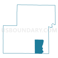
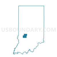
CLAY 02, Owen County, Indiana
About
Outline

Summary
| Unique Area Identifier | 579983 |
| Name | CLAY 02 |
| County | Owen County |
| State | Indiana |
| Area (square miles) | 20.35 |
| Land Area (square miles) | 20.35 |
| Water Area (square miles) | 0.00 |
| % of Land Area | 100.00 |
| % of Water Area | 0.00 |
| Latitude of the Internal Point | 39.21076560 |
| Longtitude of the Internal Point | -86.76407910 |
Maps

Graphs
Select a template below for downloading or customizing gragh for CLAY 02, Owen County, Indiana


Neighbors
Neighoring Voting District (by Name) Neighboring Voting District on the Map
- BEECH CREEK 01, Greene County, IN
- CLAY 01, Owen County, IN
- FRANKLIN, Owen County, IN
- WASHINGTON 04, Owen County, IN
Top 10 Neighboring County Subdivision (by Population) Neighboring County Subdivision on the Map
- Washington township, Owen County, IN (6,164)
- Clay township, Owen County, IN (2,600)
- Beech Creek township, Greene County, IN (2,595)
- Franklin township, Owen County, IN (1,269)